|
The Dutch established a trading post in 1616 25 kilometers up from the
mouth of the Essequibo River in what is now Guyana. Dutch sovereignty
was recognized by the Treaty of Munster in 1648. The Dutch invited
British settlement and by 1760 the British were in the majority.
Following a war between Britain and the Netherlands, the French
Revolution, and the Napoleonic wars the colonies of Demarara and
Essequibo were ceded to Britain by the London Convention in 1814. In
1833 the colony of Berbice was united with Demarara and Essequibo as
Brithish Guiana.
In 1840 Robert Schombergk surveyed the area for
Britain. He determined the limits of Dutch possession and the area
from which all trace of Spanish influence was absent. Venezuela
insisted that the Essequibo River was the natural bounday between
Venezuela and Guyana. In 1899 an international tribunal awarded 94% of
the territory to British Guiana, and in 1905 both Venezuela and
Britain accepted the boundary. Venezuela renewed its claims in the
1960's. In 1966 Guyana became independent. The protocol of
Port-of-Spain which provided a 12 year moratorium was signed by Guyana
and Venezuela in 1970, but in 1981 Venezuela refused to renew the
protocol. In 1990 the Guyanaese Defense Force and the Venezuelan Army
signed a protocol. And that is where the dispute remains.
These
stamps were also issued both as individual stamps and as souvenir
sheets, from which the following images are taken.
The map by Juan de la Cruz Cano Y Olmedilla,
cartographer to the King of Spain published his Mapa Geografico de
America Meridional in 1775. He recognized no British claim at that
time. The dark line through the middle of Guyana represents the
Essequibo River boundary claimed by Venezuela.

The
stamp shows a portion of the Mapa coro-grafico de la Nueva
Andalucia.... by Luis de Surville. All of the yellow was claimed
by Venezuela.

By 1802 the English were in
possession of the Essequibo region of what had been Dutch Guiana. Jose
Manuel Restropo's Carta del departmento del Orinoco o de Maturin,
1827, represents the official Venezuelan position at a time when
Venezuela and Ecuador were parts of Columbia. All territory west of
the Essequibo River was claimed by Venezuela. Venezuela also claimed
the coastal waters that touched Guyana.

The
Essequibo River boundary was not acceptable to the British. They would
lose a large part of their colony, and the colony would be divided as
shown in a design that displays a part of the Mapa politico de la
republica de Venezuela in 1840 by Augustin Codazzi.

The
British continued to advance extended claims, to which Venezuela made
various counter suggestions. The map, Sketch Map of British Guiana,
1840. This map appeared on a stamp in 1896, a reproduction of an
official Venezuelan map. This is the first stamp Venezuela issued
concerning the dispute. It was issued in 1896 prior to the awarding of
most of the disputed territory to Britain. It showed the Esequibo
River as the boundary between Venezuela and British Guiana.

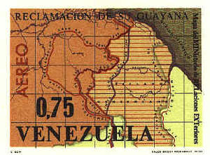
The design labled Mapa del Ministero Relaciones Exteriores is
presumably a recent map, but it is based on maps dating back to 1835.
It shows the Linea de Laudo de 1899, the line decided upon by
the arbitration commission in 1899, as well as the territory between
that line and the Essequibo River claimed by Venezuela.
The
only issues by British Guyana are overprints that say, "Essequibo is
ours."

  |
